Top 10 Beautiful Places On Earth.10. Palawan Island, Philippines: |
|
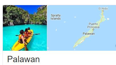
It is the most beautiful island with lots of exotic wildlife, quaint fishing villages, and UNESCO World Heritage Sites.
Palawan is the largest island of the province of Palawan in the Philippines and the fifth largest island of the country. The north west coast of the island is along the South China Sea, while the south east coast forms part of the northern limit of the Sulu Sea. Palawan Island Philippines is famous for white beaches, clear water and amazing biodiversity, also for Puerto Princesa Underground River.
For the best combination of agreeable temperatures of around 27°C and as little rain as possible, the best time to visit Palawan is between February and March. The first months of dry season can still be rainy, while the last months are usually pretty hot and humid.
Palawan is the largest island in the Palawan Province, in the western Philippines. The capital, Puerto Princesa, is known for the biodiverse Puerto Princesa Subterranean River National Park, where boats run along an underground river through vast caves. Off the east coast, Honda Bay’s islands are dotted with resorts. Farther out in the Sulu Sea, Tubbataha Reefs Natural Park has reefs teeming with marine life.
9. Seljalandsfoss, Iceland
This incredible waterfall, along Iceland's southern coast, is fed by melting water from the famed glacier-capped Eyjafjallajokull volcano.
Seljalandsfoss, also known as 'Seljalands waterfall', is a splendid waterfall that can be found in Southern Iceland. 'Seljalandsfoss', the Icelandic name of the waterfall, literally means 'selling the land of waterfalls' in English.
Seljalandsfoss is one of the most famous waterfalls of Iceland. It is very picturesque and therefore its photo can be found in many books and calendars. This waterfall of the river Seljalandsá drops 60 metres (200 ft) over the cliffs of the former coastline. It is possible to go behind the waterfall.
Amazing Facts about Seljalandsfoss, Iceland:
- Seljalandsfoss, also known as ‘Seljalands waterfall’, is a splendid waterfall that can be found in Southern Iceland.
- Seljalandsfoss is very popular in Icelandic photography, being one of Iceland’s most famous falls.
- Seljalandsfoss was part of the American reality television race, ‘The Amazing Race (6)’ in 2004, as a waypoint in the first leg.
- ‘Seljalandsfoss’, the Icelandic name of the waterfall, literally means ‘selling the land of waterfalls’ in English.
- Seljalandsfoss, from the top to the bottom, measures about 60 metres (197 feet) in height.
- Seljalandsfoss is formed by the Seljalandsá River, which runs over the edge of a volcanic cliff.
- Seljalandsfoss can be viewed from all angles, as a walking trail passes behind the falls, and tours to the falls are also available.
- Seljalandsfoss features a small cascade at the top of the falls, with smaller waterfalls surrounding it.
- The cliff of the Seljalandsfoss is believed to have been once part of the coastline of Iceland.
- Seljalandsfoss partially freezes in winter, and the surroundings are covered in snow and ice.
8. Plitvice Lakes National Park, Croatia
Plitvice is considered one of the most beautiful national parks in the world.
Plitviče Lakes National Park is a 295-sq.-km forest reserve in central Croatia. It's known for a chain of 16 terraced lakes, joined by waterfalls, that extend into a limestone canyon. Walkways and hiking trails wind around and across the water, and an electric boat links the 12 upper and 4 lower lakes. The latter are the site of Veliki Slap, a 78 m-high waterfall.
Plitvice Lakes National Park is one of the oldest and largest national parks in Croatia. In 1979, Plitvice Lakes National Park was added to the UNESCO World Heritage register.
The national park was founded in 1949 and is in the mountainous karst area of central Croatia, at the border to Bosnia and Herzegovina. The important north–south road that passes through the national park area connects the Croatian inland with the Adriatic coastal region.
The protected area extends over 296.85 square kilometres (73,350 acres).Each year, more than 1 million visitors are recorded.
Fun Facts about Plitvice Lakes National Park, Croatia:
1. Plitvice Lakes National Park is home to 16 different lakes. The Plitvice Lakes National Park is best known for its 16 cascading lakes and more than 90 waterfalls. The two largest lakes in the Plitvice system are Prošćansko and Kozjak. There are 12 upper lakes and 4 lower lakes. The highest waterfall in Croatia can be found in the Lower Lakes area: The Great Waterfall (Veliki Slap).
2. Plitvice Lakes change color by the second. Within the blink of an eye, you can see blue, green, aquamarine and turquoise. This is due to the way the sun hits the water and the number of organisms and minerals. At any given time, the Plitvice Lakes never look the same as they did the day before. The lakes are consequently notorious for their fluctuating water colours. The water colours range from a bright emerald green, a deep blue, or a faded grey. The lakes are continuously changing colour according to the amount of minerals or organisms, as well as the angle of sunlight. The most important ingredient causing the water to turn blue or green is calcium carbonate from limestone rocks.
3. In total, about 5 square kilometers (2 square miles) of the park is covered with lakes.
4. The origin of the name ‘Plitvice’, most likely comes from the river called ‘Plitvica’, that flows into the lakes.
5. Plitvice Lakes National Park has over 320 types of butterflies and moths.
6. Legend of the Black Queen: The origin story of the Plitvice Lakes involves a mysterious lady. Prošćansko Lake is connected to the ‘Legend of the Black Queen’. The legend on ‘Prošnja’ tells the story about a period of drought in the region. Inhabitants called upon the magic queen to help them, to which she responded by creating the Plitvice lakes. Accordingly, Prošćansko Jezero was believed to be the first lake she created.
7. Legend of the Cave Monk: The Lower Lakes canyon area also includes the limestone Šupljara Cave. The Šupljara Cave is famous for a legend about a wise monk or hermit (kaluđer) that was believed to live in either Šupljara or Golubnjača Cave. According to reports, people used to come to the Plitvice lakes and visit the monk to ask for advice. Hence, the nearby Kaluđerovo Jezero’s name translates into “Hermit’s Lake”.
8. Bizarre Cave Creatures: Amazingly, the caves of Plitvice Lakes have been inhabited since ancient times. Even the bones of an extinct Pleistocene Cave Bears have been found inside the caves. Since the caves remain undisturbed by the bustle of the city or industrial plants, many unique species still live inside the tunnels. The humid caves have constant temperatures around 10.5°C, creating unique conditions that are only suitable for specially adapted cave fauna. For example, one of these weird animals is one of the tiniest snails on the planet: the Zospeum isselianum is a 1 mm snail with transparent body and shell. Other animals include endemic pseudoscorpions, moths, crickets, and millipedes.
7. Algar de Benagil, Portugal
This natural grotto is a real gem on the Algarve coast, one of the most impressive sea caves in Europe.
This natural grotto is a real gem on the Algarve coast, one of the most impressive sea caves in Europe.
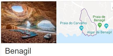
Benagil is a small Portuguese village on the Atlantic coast in the municipality of Lagoa, Algarve, in Portugal. Up to the late 20th century, the village's economy was based on ocean fishing. Now it is a tourist area with a widely used beach: Praia de Benagil.
Praia de Benagil is a magnificent beach near Lagoa. The beach is most famous for its sensational cave called Algar de Benagil. This cave has a round hole in the ceiling that frames the beautiful blue sky inside.
The Beach: Praia de Benagil is a relatively small beach, sitting between impressive gold-coloured cliffs. The cliffs also protect the beach from winds.
Algar de Benagil (the eye): Near Praia de Benagil is an impressive cave, called Algar de Benagil. The cave is located just around the corner of the left side of the beach. When you arrive there, you will be amazed. Inside the cave is a small, magical beach. From inside the cave, you will see the blue sky through an opening in the ceiling, also known as the eye.
This photogenic cave is very popular among photographers, and it can be seen on many postcards. To enter Algar de Benagil, you have to go through one of two arches. The sea outside the cave is also a great location for snorkeling. The water is crystal clear and the surroundings are amazing.
6. Cliffs of Moher, Ireland
These soaring cliffs in County Clare are one of Ireland's most famous tourist attractions. The maximum height of Cliffs is 214 m. This natural sanctuary is home to some 30,000 birds from 20 different species.
These soaring cliffs in County Clare are one of Ireland's most famous tourist attractions. The maximum height of Cliffs is 214 m. This natural sanctuary is home to some 30,000 birds from 20 different species.

The Cliffs of Moher are sea cliffs located at the southwestern edge of the Burren region in County Clare, Ireland. They run for about 14 kilometres.
The Cliffs of Moher are located on the west coast of Ireland close to Liscannor village in Co. Clare. The closest airport is Shannon International Airport approximately 50 minutes by road.
The Cliffs of Moher have appeared in numerous media. In cinema, the cliffs have appeared in several films, including The Princess Bride (1987) (as the filming location for "The Cliffs of Insanity"), Harry Potter and the Half-Blood Prince (2009), and Leap Year (2010).
The Cliffs of Moher is by far one of the most popular tourist destinations in Ireland, attracting over one million visitors each year. The Cliffs of Moher are approximately 14 km long, and they rise to 214 meters (just above 700ft) at their highest point, just north of O'Brien's Tower.
Irish Legends : Many folklore stories surround the cliffs of Moher. One famous one is about an unusual rock formation, at the most southerly point. It closely resembles a woman’s head looking out to the sea when viewed from the North. This is called Hag’s Head. Local Irish legend tells of how an old hag, (a colloquial term for an older, ugly lady or witch) called Mal. She fell in love with the Irish hero Cú Chulainn and chased him all over Ireland. Cú Chulainn did not return her feelings. He finally ended up at Loop Head in Co.Clare, seemingly cornered by Mal. As he was a superhero of sorts, he saw an exit route and made his escape by hopping across sea stacks towards the Cliffs of Moher, using them like stepping-stones. Mal, not so nimble as he, went following after him but lost her footing and was dashed to pieces against the cliff. They say the sea turned red where she fell, all the way to the Cliffs. Malbay is thought to have been named after her.

Fun Facts about Cliffs of Moher:
- The Cliffs of Moher are cliffs found in County Clare in the Burren area, on the coast of Europe’s Ireland, that look out over the Atlantic ocean.
- Huge visitor numbers, 1.5 million per year. The Cliffs attract around 1.5 million people per year. Second only to the Guinness Storehouse in Dublin in terms of the highest attraction visitor numbers in Ireland.
- The ‘Cliffs of Moher’ are also known as ‘Aillte an Mhothair’ in Irish.
- They are believed to be 320 million years old. Formed during the upper Carboniferous period, you will see layers of of Namurian sandstone, siltstone and shale. The oldest rocks being at the bottom, which is why you see so many varied colours.
- The Cliffs of Moher range 120 to 214 metres (390 to 702 feet) in height from water level, and spread for 8 kilometres (5 miles).
- One can spot a huge range of wildlife in the area from grey seals, Dolphins and basking sharks to Atlantic Puffins. The Atlantic puffins live in big colonies at isolated parts of the cliffs and there are estimated to be 30,000 pairs present at peak season.
- The Cliffs of Moher are made mainly of sedimentary rock, particularly shale and sandstone.
- The Cliffs of Moher are home to 20 species of bird, with seabirds numbering over 30,000 pairs, including puffins, razorbills, guillemots and others, including some endangered species including peregrine falcons.
- One of the more less known facts, is that the Cliffs appeared in this legendary film released in 1987, as “The Cliffs of insanity”. Other film appearances include: Ryan’s Daughter & Harry Potter & the Half Blood Prince.
- The Cliffs of Moher contains a large amount of fossils, including trails left by sea creatures.
- The Cliffs of Moher are eroded by wind, wave, rain and ice, and this has created caves, and isolated landforms in the ocean.
- The Cliffs of Moher are a section of the Burren and Cliffs of Moher Geopark that became a member of the Global Geoparks Network in 2011, that is supported by UNESCO.
- The Cliffs of Moher take their name from an old fort called, Mothar or Moher, which was at Hag’s Head. It was destroyed in 1808 to supply material for a lookout tower (Moher tower), which was intended to warn of a French invasion.
5. Great Barrier Reef and Whitehaven beach, Australia
Diverse aquatic species include leatherback turtles and clown fish, the Great Barrier Reef needs no introduction. The world's largest coral reef system composed of over 2,900 individual reefs and 900 islands stretching for over 2,300 kilometres over an area of approximately 344,400 square kilometres (133,000 sq mi), the Great Barrier Reef can be seen from outer space and is the world's biggest single structure made by living organisms.
Diverse aquatic species include leatherback turtles and clown fish, the Great Barrier Reef needs no introduction. The world's largest coral reef system composed of over 2,900 individual reefs and 900 islands stretching for over 2,300 kilometres over an area of approximately 344,400 square kilometres (133,000 sq mi), the Great Barrier Reef can be seen from outer space and is the world's biggest single structure made by living organisms.

Whitehaven Beach is a 7 km stretch along Whitsunday Island, Australia. The island is accessible by boat, seaplane & helicopter from Airlie Beach, as well as Hamilton Island. It lies across from Stockyard Beach, better known as Chalkie's Beach, on Haslewood Island.
The Great Barrier Reef is the world's largest coral reef system composed of over 2,900 individual reefs and 900 islands stretching for over 2,300 kilometres over an area of approximately 344,400 square kilometres. The reef is located in the Coral Sea, off the coast of Queensland, Australia. The Great Barrier Reef can be seen from outer space and is the world's biggest single structure made by living organisms. This reef structure is composed of and built by billions of tiny organisms, known as coral polyps. It supports a wide diversity of life and was selected as a World Heritage Site in 1981.
The Great Barrier Reef is the world's largest coral reef system composed of over 2,900 individual reefs and 900 islands stretching for over 2,300 kilometres over an area of approximately 344,400 square kilometres. The reef is located in the Coral Sea, off the coast of Queensland, Australia. The Great Barrier Reef can be seen from outer space and is the world's biggest single structure made by living organisms. This reef structure is composed of and built by billions of tiny organisms, known as coral polyps. It supports a wide diversity of life and was selected as a World Heritage Site in 1981.

Fun Facts About : Great Barrier Reef and Whitehaven beach, Australia
- It is famous all over the world, for its colourful corals and fascinating fishes.
- Finding Nemo is almost guaranteed here - In real life, Nemo, the wayward clownfish from the Disney movies Finding Nemo and Finding Dory, would be pretty easy to find. The adorable little orange and white clownfish is just one of 30 clownfish species that inhabits the Great Barrier Reef, living in large numbers among the corals and anemones. The easiest way to spot Nemo for yourself is to sign up to a diving or snorkelling trip, or set sail in a glass-bottomed boat.
- The reef is huge - At 344,400km2, the Great Barrier Reef is around the same size as Finland. That’s 16.5 times the size of Wales and the equivalent of 70 million football pitches. Not only that, but it’s the largest living structure on earth – so large in fact that it’s also the only living structure on earth that can be seen from space.
- The reef is made up of over 900 islands - When it comes to islands, there’s a plethora of choice on the Great Barrier Reef. Not all of them are inhabited, or have much more than a patch of sand and a smattering of forest, but all of them will live up to your desert island ideals. Lady Elliot Island, the southernmost one, is known for its turtles and manta rays, while Lizard Island is home to Australia’s northernmost island resort, and rather swanky it is too. If you want to explore a few you could try island hopping the Whitsundays, where you’ll also find the legendary Whitehaven Beach.
- There's a huge diversity of life.- The Great Barrier Reef is home to 10% of the world’s fish species, including snappers, wrasse and coral trout. But it’s not just about the fish: 10,000 dugongs, 30 species of whales and dolphins, and six species of sea turtle live here, as well as 215 bird species and 5,000 types of mollusc. You’ll also find 17 varieties of sea snake, 134 sharks and rays (including the fearsome great white) plus the occasional saltwater crocodile.
- It's a World Heritage site - The Great Barrier Reef was designated a UNESCO World Heritage site in 1981. In fact, it is the only place on the planet where two World Heritage sites sit side by side, together with its neighbour the Daintree Rainforest in Cape Tribulation. This gives rise to Cape Tribulation’s advertising slogan ‘Where the Rainforest Meets Reef’. Furthermore, in 1997, CNN named the Great Barrier Reef as one of the Seven Natural Wonders of the World, along with the Grand Canyon and Mount Everest.
- The reef is 500,000 years old - Yes that’s right; the reef began to form over half a million years ago, when sea water temperatures had increased enough to allow coral to breed. The corals grow at a rate of 1-25 centimeters per year, with today’s reef made up of newer corals thought to be around 6,000 years old, growing on the dead older corals. Rising sea levels around 20,000 years ago allowed the corals to grow higher, forming the cays and reefs we see today.
- The reef is pretty shallow - Good news for divers: the Great Barrier Reef has an average depth of just 35 metres. Most corals and fish grow near to the surface where there’s more light, allowing snorkelers and scuba divers to explore at leisure, especially along the Inner Reef. If you head to the Outer Reef though you’ll find out what Nemo was talking about when he feared the mysterious ‘drop-off’, as here the Continental Shelf drops over 1.2 miles into the dark waters below.
4. Antelope Canyon, Arizona
Majestic sandstone creates the appearance of fire at Antelope Canyon.
Antelope Canyon is a slot canyon in the American Southwest, on Navajo land east of Page, Arizona. It includes two separate, scenic slot canyon sections, referred to as Upper Antelope Canyon, and Lower Antelope Canyon.
Depth: about 120 feet (37 m)
Length: Upper Antelope Canyon: about 660 feet (200 m); Lower Antelope Canyon: about 1,335 feet (407 m)
Floor elevation: 3,704 ft (1,129 m)
Antelope Canyon is a slot canyon in the American Southwest, on Navajo land east of Page, Arizona. It includes two separate, scenic slot canyon sections, referred to as Upper Antelope Canyon (or The Crack), and Lower Antelope Canyon (or The Corkscrew). The Navajo name for Upper Antelope Canyon is Tsé bighánílíní, which means 'the place where water runs through rocks'. Lower Antelope Canyon is Hazdistazí (called "Hasdestwazi" by the Navajo Parks and Recreation Department), or 'spiral rock arches'. Both are in the LeChee Chapter of the Navajo Nation. They are accessible by guided tour only.
Antelope Canyon was formed by the erosion of Navajo Sandstone due to flash flooding and other sub-aerial processes. Rainwater, especially during monsoon season, runs into the extensive basin above the slot canyon sections, picking up speed and sand as it rushes into the narrow passageways. Over time the passageways eroded away, deepening the corridors and smoothing hard edges to form characteristic "flowing" shapes. Flooding in the canyon still occurs. A flood occurred October 30, 2006 that lasted 36 hours, and caused the Tribal Park Authorities to close Lower Antelope Canyon for five months.
Antelope Canyon is a popular location for photographers and sightseers, and a source of tourism business for the Navajo Nation. It has been accessible by tour only since 1997, when the Navajo Tribe made it a Navajo Tribal Park. Besides the Upper and Lower areas, there are other slots in the canyon that can be visited, such as the Canyon X which is also part of the same drainage as Antelope Canyon. All visits are through one of several licensed tour operators. It is not possible to visit the Canyon independently.
Antelope Canyon is a slot canyon located on Navajo land east of Page, Arizona, United States. A slot canyon is a narrow canyon, formed by the wear of water rushing through rock. A slot canyon is significantly deeper than it is wide. The mysterious and beautiful Antelope Canyon is one of the most spectacular slot canyons in the world. It is sculpted into beautiful undulating curves and hollows that vary from one to 3 meters (3.2 to 9.8 feet)wide and up to 50 meters (164 feet) deep. Antelope Canyon includes two separate, scenic slot canyon sections, referred to individually as Upper Antelope Canyon and Lower Antelope Canyon. In English, Upper Antelope Canyon is called “The Crack” but the Navajo know it as Tsé bighánílíní or “the place where water runs through rocks.”
Upper Antelope Canyon is more popular for two reasons. First, its entrance and entire length are at ground level, requiring no climbing. Second, beams or shafts of direct sunlight radiating down from openings at the top of the canyon are much more common in Upper than in Lower. Beams occur most often in the summer months, as they require the sun to be high in the sky. Winter colors are more muted. Summer months provide two types of lighting. Light beams start to peek into the canyon March 20 and disappear October 7 each year.
Lower Antelope Canyon has been given the nickname “The Corkscrew” while the Navajo term referencing it is Hazdistazí for “spiral rock arches.”. Lower Antelope Canyon is located a few miles from Upper Antelope. This canyon is a little shallower than Upper Antelope Canyon and the famous light beams do not occur there as often as in the other.
Prior to the installation of metal stairways, visiting Lower Antelope Canyon required climbing in certain areas. Even following the installation of stairways, it is a more difficult hike than Upper Antelope. It is longer, narrower in spots, and even footing is not available in all areas. Despite these limitations, it draws a considerable number of photographers, though casual sightseers are much less common there than in the Upper canyon.
Antelope Canyon got its name from the pronghorn antelopes that once grazed in the area.
Today, Antelope Canyon is a popular location for photographers and sightseers, and a source of tourism business for the Navajo Nation. It has been accessible by permit only since 1997, when the Navajo Tribe made it a Navajo Tribal Park.
Antelope Canyon is the most-visited and most-photographed slot canyon in the Southwest America.
Flash flooding still occurs in the canyon and may, at times, result in up to several months of closing.
On August 12, 1997, eleven tourists were killed in Lower Antelope Canyon by a flash flood. Very little rain fell at the site that day, but an earlier thunderstorm had dumped a large amount of water into the canyon basin, 11 kilometers (7 miles) upstream.
- Antelope Canyon is primarily a water eroded rock canyon located near the city of Page, in the northern part of the state of Arizona, in the United States.
- Antelope Canyon is a slot canyon known for its smooth, wavy walls of sandstone, caused mainly by flash flooding and rain.
- Antelope Canyon is a popular tourist location, particularly for photography and sightseeing, and is said to be the most photographed slot canyon in the world.
- Antelope Canyon has two parts, an upper and a lower section, called ‘the Crack’ and ‘the Corkscrew’ respectively, and the Upper Canyon is easily accessible and relatively flat, whereas the Lower Canyon requires significant quantities of stairs to access the site.
- The area surrounding Antelope Canyon has historically been used as a site for livestock grazing and the area is part of the Lake Powell Navajo Tribal Park.
- Some curved parts of Antelope Canyon beautifully reflect light, and light beams can be seen in other canyon locations, especially in the Upper Canyon during summer.
- Before European discovery, Antelope Canyon was the home to numerous pronghorn antelopes, hence its name, and the native Navajo people call the Upper Canyon ‘Tsé bighánílíní’, meaning ‘the place where water runs through rocks’ and the Lower Canyon ‘Hasdestwazí’, which means ‘spiral rock arches’.
- Antelope Canyon is only accessible via a guided tour, and it has been open to commercial tours since 1987.
- Flash flooding in Antelope Canyon is still common, causing 11 fatalities in 1997, and death prevention measures are now in place, including radios and loud alarms.
- The distance between Antelope Canyon’s walls range from 1-3 metres (3.2 to 9.8 feet) wide and run up to 50 metres (6.5 to 164 feet) deep, and the Upper Canyon sits 1219 metres (4000 feet) above sea level and the walls are 36.5 metres (120 feet) tall.
- Antelope Canyon is a slot canyon located on Navajo land east of Page, Arizona, United States.
- A slot canyon is a narrow canyon, formed by the wear of water rushing through rock. A slot canyon is significantly deeper than it is wide.
- The mysterious and beautiful Antelope Canyon is one of the most spectacular slot canyons in the world.
- It is sculpted into beautiful undulating curves and hollows that vary from one to 3 meters (3.2 to 9.8 feet)wide and up to 50 meters (164 feet) deep.
- Antelope Canyon includes two separate, scenic slot canyon sections, referred to individually as Upper Antelope Canyon and Lower Antelope Canyon.
- In English, Upper Antelope Canyon is called “The Crack” but the Navajo know it as Tsé bighánílíní or “the place where water runs through rocks.”
3. Iguazu Falls, Argentina/Brazil border
One of the modern natural wonders of the world, this chain of mini waterfalls is one of the planet's most awe-inspiring sights. A visit is an awe-inspiring visceral experience, and the power and noise of the cascades – a chain of hundreds of waterfalls nearly 3km in extension – is something you won't forget. The falls lie split between Brazil and Argentina in a large expanse of national park, much of it rainforest teeming with unique flora and fauna. Iguazu Falls, Brazil was named one of the new natural seven wonders of the world. Igazu Falls is the world's largest waterfall system, so there's definitely no shortage of views here. With 275 different drops, it's eye catching and inspiring from every vantage point.
Iguazú Falls or Iguaçu Falls are waterfalls of the Iguazu River on the border of the Argentine province of Misiones and the Brazilian state of Paraná. Together, they make up the largest waterfall in the world. The falls divide the river into the upper and lower Iguazu. The Iguazu River rises near the heart of the city of Curitiba. For most of its course, the river flows through Brazil; however, most of the falls are on the Argentine side. Below its confluence with the San Antonio River, the Iguazu River forms the boundary between Argentina and Brazil.
Legend has it that a deity planned to marry a beautiful woman named Naipí, who fled with her mortal lover Tarobá in a canoe. In a rage, the deity sliced the river, creating the waterfalls and condemning the lovers to an eternal fall. The first European to record the existence of the falls was the Spanish Conquistador Álvar Núñez Cabeza de Vaca in 1541.
Iguazú Falls or Iguaçu Falls are waterfalls of the Iguazu River on the border of the Argentine province of Misiones and the Brazilian state of Paraná. Together, they make up the largest waterfall in the world. The falls divide the river into the upper and lower Iguazu.
Address: Misiones Province, Argentina
Elevation: 195 m
Height: 82 m
Width: 2,700 m
Number of drops: 275
Fun Facts about Iguazu Falls:
1. Two-thirds of Iguazu Falls are on the Argentina side. Of all the waterfalls in the world, Iguazu has the highest annual average flow, more than Niagara Falls. Iguazu Falls is taller than, and twice as wide as Niagara Falls. Iguazu Falls was formed as the result of a volcanic eruption.
2. THE WATERFALL WAS FORMED DUE TO A VOLCANIC ERUPTION. However there is a legend to explain the falls: Iguazu Falls are the result of a volcanic eruption which left a large crack in the earth. Legend says that a god wanted to marry a beautiful girl named Naipi against her will. She tried to escape with her mortal lover Taroba in a hand carved canoe on the river. When the god found out he was so outraged that he split the river into two so that the two lovers would be condemned to an eternal fall and thus Iguazu Falls were created.
3. With more than 275 falls, the Iguazu are the most majestic of water falls. The most scenic one is the curved cataract christened the 'devils throat' that has 14 falls that drop to a height of 350 feet.
4. The rainforest delta surrounding the falls boasts a whopping 2,000 species of plants.
5. Iguacu is wider than Lake Victoria on the Zambian/Zimbabwean border. However due to the outcrops that interrupts its water falls, it is considered smaller.
6. There is a scenic rainbow formed on the waterfalls caused by the refraction of light against the mist caused by thundering waters.
7. Iguazu's surrounding forest is home to the opossum, he only marsupial that is found outside Australia.
8. The rainy season of November through March sees a surge in the waterfalls water that can go to as high as 450,000 cubic feet per second.
9. There is a point in the water falls that an observer can stand and get enveloped by about 260 degrees of waterfalls.
10. First Lady Eleanor Roosevelt, upon seeing the Iguazu Waterfalls felt pity on the American Waterfalls called the Niagara. She said, "Poor Niagara".
11. The best time to see the waterfall is during spring and fall. The summers are extremely humid and hot and during the winters, the waters will have receded.
12. When translated into English, the word Iguazu roughly means ‘big water’. The Iguazu River forms the boundary between Argentina and Brazil before its confluence with the San Antonio River. Iguazu Falls are waterfalls of this river located on the border of Brazilian state Parana and Argentine province Misiones. The falls divide the river into upper and lower Iguazu.
13. Iguazu Waterfalls are second only to Victoria Waterfalls in size.
14. IGUAZU FALLS FEATURED IN AN INDIANA JONES MOVIE. Iguazu Falls have featured in several movies including: Moonraker (1979), The Mission (1986), Mr. Magoo (1997), Miami Vice (2006) and Indiana Jones and the Kingdom of The Crystal Skull (2008).
2. Moraine Lake, Canada
Moraine Lake may only be half the size of its nearby neighbor Lake Louise, but it's even more scenic. Situated in the beautiful Valley Of The Ten Peaks in Banff National Park, this glacier-fed lake turns the most intense and vivid shade of turquoise blue. The setting of the surrounding majestic mountain peaks makes the scene almost surreal.
Moraine Lake is a glacially fed lake in Banff National Park, 14 kilometres (8.7 mi) outside the Village of Lake Louise, Alberta, Canada. It is situated in the Valley of the Ten Peaks, at an elevation of approximately 1,884 metres (6,181 ft). The lake has a surface area of 50 hectares (120 acres).
The lake, being glacially fed, does not reach its crest until mid to late June. When it is full, it reflects a distinctive shade of azure blue. The unique color is due to the refraction of light off the rock flour deposited in the lake on a continual basis by surrounding glaciers.
Fun Facts About Moraine Lake:
Moraine Lake is nicknamed the lake with the twenty dollar view, since it was featured on the backside of the 1969 and 1979 issues of the Canadian Twenty Dollar bill.
The image of Moraine Lake also appears in:
• In one of the main preview pictures for Google’s operating system Android, Moraine lake was used as a background picture.
• In one of Windows 7’s backgrounds in the “Canada” and the “Winter” series; and in the login screen of Windows 10.
• In the Bing homepage on October 13, 2009, on October 2, 2013, and again on September 10, 2014.
Moraine Lake is home to a variety of fish species including trout, Mountain Whitefish, and Lake Whitefish.
One of the major threats facing Moraine Lake and other glacial lakes around the world is the thawing of glaciers due to global warming.
- Moraine Lake is a lake that has an area of 0.5 kilometers squared (0.19 miles squared) and a depth of up to 14 meters (46 feet) and is easily accessible by road, although the road is closed from October to May.
- Moraine Lake has been featured on the Canadian $20 note in 1969 and 1979, and it is one of Canada’s most commonly photographed places.
- Moraine Lake is quite picturesque, with the Ten Peaks, a group of ten mountains, rising above and surrounding the lake, and has been featured as background options on computers and electronic devices.
- Moraine Lake is the home of wildlife such as grizzly bears, ground squirrels, chipmunks, marmots and pikas (small rabbit-like mammals).
- Moraine Lake is so called due to a ‘moraine’, a pile of glacial rocks and boulders that was formed by the Wenkchemna Glacier next to the lake.
- Moraine Lake has a water source from Fay Glacier and Larch Creek, and is the source of Moraine Creek.
- Moraine Lake is located in Banff National Park, Alberta, Canada, in the Valley of Ten Peaks, and has a surface elevation of approximately 1884 meters (6181 feet) above sea level.
- Moraine Lake displays a beautiful blue hue when it is at full capacity, due to ‘rock flour’ or ‘glacial flour’, tiny particles of rock, in the lake refracting light.
- The Moraine Lake area is the home to trails for hiking, as well as Moraine Lake Lodge, which has accommodation that can be rented for short getaways.
- Canoeing is a popular sport performed on the surface of Moraine Lake and can be arranged through the Lodge.
1. Salar de Uyuni, Bolivia
The world's largest salt flats, spanning 4086 miles (10,582 sq. km), Salar de Uyuni is unlike anywhere else on earth. This awe-inspiring landscape is comprised of glistening white salt, and is completely flat creating the mesmerising reflections.
Salar de Uyuni, amid the Andes in southwest Bolivia, is the world’s largest salt flat. It’s the legacy of a prehistoric lake that went dry, leaving behind a desertlike, nearly 11,000-sq.-km. landscape of bright-white salt, rock formations and cacti-studded islands. Its otherworldly expanse can be observed from central Incahuasi Island. Though wildlife is rare in this unique ecosystem, it harbors many pink flamingos. The salt flats formation is due to evaporation.
Salar is salt flat in Spanish. Uyuni originates from the Aymara language and means a pen (enclosure); Uyuni is a surname and the name of a town that serves as a gateway for tourists visiting the Salar. Thus Salar de Uyuni can be loosely translated as a salt flat with enclosures, the latter possibly referring to the "islands" of the Salar; or as "salt-flat at Uyuni (the town named 'pen for animals')".
Aymara legend tells that the mountains Tunupa, Kusku, and Kusina, which surround the Salar, were giant people. Tunupa married Kusku, but Kusku ran away from her with Kusina. Grieving Tunupa started to cry. Many locals consider the Tunupa an important deity and say that the place should be called Salar de Tunupa rather than Salar de Uyuni.
Salar de Uyuni is estimated to contain 10 billion tons of salt of which less than 25,000 tons is extracted annually. Vast reserves of untapped lithium lie beneath the salt flat, and in the early 21st century the Bolivian government discussed options and feasibility for its extraction and production. It contains 50% to 70% of the world’s known lithium reserves.
